
The Mississippi River is getting a lot of attention in the news these days, but it's not good news. The "trickle down" effect is not only related to the economy, but can also be found at work in Nature, as river cities from Illinois to New Orleans prepare for what has been predicted as one of the worst floods in decades.
Its name means "Father of Waters," but in the next couple of weeks, a lot of people will probably realize why the river is also called the Mighty Mississippi.
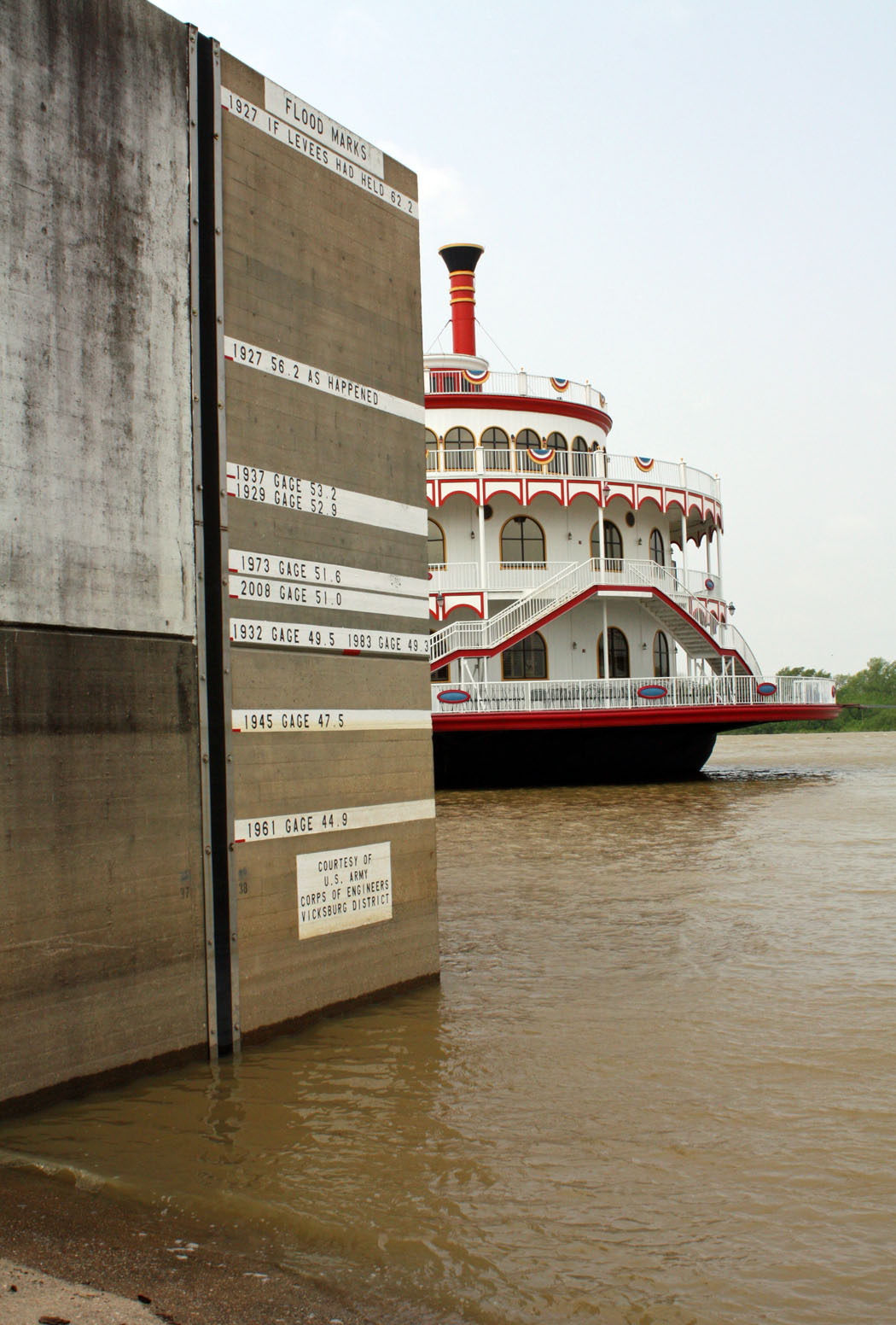
The predictions for the river's crest here in Vicksburg, are holding steady, despite more than two inches of rain in the area recently. Yesterday, the river level was at 40.3 feet, and is expected to crest at 53.2 feet, the highest since 1937.
In 2008, the river topped out at 50.9 feet, and here are two pictures I captured of the river then ...


If current crest predictions hold, all riverside roadways in Vicksburg, will go under water according to a report issued Tuesday by the Board of Mississippi Levee Commissioners. The Warren County supervisors have declared a disaster ahead of the looming flood waters, and preparations are being made to house flood evacuees at the Vicksburg Convention Center, if the need arises.
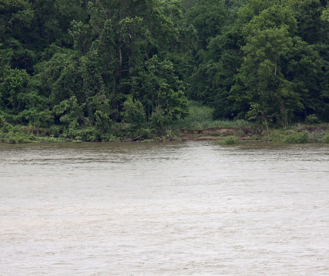
Here is the way things looked yesterday when I made several stops along the river in Vicksburg.
The river is currently at the 40.3 mark, and is predicted to hit the 1937 level of 53.2, so you can see how much higher it will be on the gauge in this picture:


After leaving the water front, I headed toward the double bridges crossing the river, and drove up to the top of the parking garage of Ameristar Casino "to see what I could see."


We have been plagued by lingering March winds along with April showers, and the ragged edge of the flag atop the railroad bridge is showing signs of its constant battering by the wind ...


Look at the treacherous currents!


The benchmark 1927 flood reached 56.2 feet on today’s gauges, and it would have been 62 feet had the levees held.

I'm glad I wasn't around to take pictures of it back then.
In the next few days,I'll try to capture a photo record of the river's water levels, and will keep you posted. Perhaps, we will get lucky and the Mighty Mississippi will become Ol' Man River by the time it gets to Vicksburg. We can always hope, I guess!


8 comments:
Very informative! I hope that everyone will be safe with the rising water.
So glad that yesterday is behind us...a long scary day~
It is hard to imagine water levels that high. I wonder if it will impact the Red? I always love pictues from the River Front in Vicksburg.
Carolyn
Very scary! I hope you fared o.k. during all the terrible storms!
The River here in Clarksville,Mo. about 70 miles from St.Louis, Mississippi is holding now. It crested yesterday. They had predicted it would rise again today, but so far is still going down. I wish we knew what was next. We are prepared, just in case. Richard at My Old Historic House.
Janie,
I hope and trust that you are all well and safe, and were spared the destruction that was so wide-spread.
I've finally got through to a cousin in Birmingham and a niece in Tuscaloosa, and they are both safe, as are their homes and families.
rachel
I hope everything works out...nice shots..
Indeed it is the same river. I just posted some pictures of the river beginning to recede here in Saint Paul. It stayed a flood stage for nearly one month, but again not the worst we've ever had here. The highest one here -- at least in recent memory -- was 1965. I couldn't get to the place where that sign is on a levee to get a picture to compare this year's flood, which was I think 7 feet lower than that. If it had gone to the 65 level I would have had to evacuate because the city would have had to turn off the utilities to the building and one can't live legally in a place without water.
Whenever I walk along the river I'm impressed with the power of the current and yet how absolutely quiet it is.
I just saw Richard's comment. I was wondering how things were going in Clarksville.
I know there was water over the road to the ferry, down by St Peters, the other day. We haven't been to the bottoms, so haven't seen how high the river is. I know it was up at St Louis, the other day. The Missouri River and Mississippi River join at St Louis. Both these rivers cause havoc. There are several rivers in Missouri. The Black River got into Poplar Bluff this week.
Yes, the Mississippi is powerful!
Post a Comment